


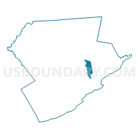
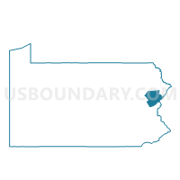
STROUD TWP DIST 01, Monroe County, Pennsylvania
About
Outline

Summary
| Unique Area Identifier | 661243 |
| Name | STROUD TWP DIST 01 |
| County | Monroe County |
| State | Pennsylvania |
| Area (square miles) | 5.59 |
| Land Area (square miles) | 5.48 |
| Water Area (square miles) | 0.11 |
| % of Land Area | 98.10 |
| % of Water Area | 1.90 |
| Latitude of the Internal Point | 41.03464360 |
| Longtitude of the Internal Point | -75.19985310 |
Maps

Graphs
Select a template below for downloading or customizing gragh for STROUD TWP DIST 01, Monroe County, Pennsylvania


Neighbors
Neighoring Voting District (by Name) Neighboring Voting District on the Map
- EAST STROUDSBURG DIST 05, Monroe County, PA
- EAST STROUDSBURG DIST 06, Monroe County, PA
- PARADISE TWP Voting District, Monroe County, PA
- POCONO TWP DIST 04, Monroe County, PA
- PRICE TWP Voting District, Monroe County, PA
- SMITHFIELD TWP DIST 01, Monroe County, PA
- STROUD TWP DIST 02, Monroe County, PA
- STROUD TWP DIST 03, Monroe County, PA
- STROUD TWP DIST 04, Monroe County, PA
- STROUDSBURG WD 01, Monroe County, PA
- STROUDSBURG WD 02, Monroe County, PA
Top 10 Neighboring County Subdivision (by Population) Neighboring County Subdivision on the Map
- Stroud township, Monroe County, PA (19,213)
- Pocono township, Monroe County, PA (11,065)
- East Stroudsburg borough, Monroe County, PA (9,840)
- Smithfield township, Monroe County, PA (7,357)
- Stroudsburg borough, Monroe County, PA (5,567)
- Price township, Monroe County, PA (3,573)
- Paradise township, Monroe County, PA (3,186)
Top 10 Neighboring Place (by Population) Neighboring Place on the Map
- East Stroudsburg borough, PA (9,840)
- Arlington Heights CDP, PA (6,333)
- Stroudsburg borough, PA (5,567)
Top 10 Neighboring Unified School District (by Population) Neighboring Unified School District on the Map
- Pocono Mountain School District, PA (64,586)
- East Stroudsburg Area School District, PA (47,915)
- Stroudsburg Area School District, PA (34,609)
Top 10 Neighboring State Legislative District Lower Chamber (by Population) Neighboring State Legislative District Lower Chamber on the Map
- State House District 189, PA (76,401)
- State House District 176, PA (70,533)
- State House District 139, PA (67,006)
Top 10 Neighboring State Legislative District Upper Chamber (by Population) Neighboring State Legislative District Upper Chamber on the Map
- State Senate District 20, PA (273,416)
- State Senate District 18, PA (267,805)
- State Senate District 22, PA (255,871)
- State Senate District 14, PA (250,131)
Top 10 Neighboring 111th Congressional District (by Population) Neighboring 111th Congressional District on the Map
Top 10 Neighboring Census Tract (by Population) Neighboring Census Tract on the Map
- Census Tract 3010.01, Monroe County, PA (10,169)
- Census Tract 3004.02, Monroe County, PA (6,430)
- Census Tract 3002.02, Monroe County, PA (6,356)
- Census Tract 3009, Monroe County, PA (6,241)
- Census Tract 3008, Monroe County, PA (5,567)
- Census Tract 3007, Monroe County, PA (5,496)
- Census Tract 3005.02, Monroe County, PA (4,760)
- Census Tract 3006, Monroe County, PA (4,344)
- Census Tract 3001.01, Monroe County, PA (3,573)